Henri becomes a hurricane as it moves toward the Northeast
Henri was veering a bit further west than originally expected, and if that track holds, it would have eastern Long Island in its bull’s-eye rather than New England, which hasn’t taken a direct hit from a hurricane since Hurricane Bob in 1991, a Category 2 storm that killed at least 17 people.
New York hasn’t had a direct hit from a powerful cyclone since Superstorm Sandy wreaked havoc in 2012. Some of the most important repairs from that storm have been completed, but many projects designed to protect against future storms remain unfinished.
The population of Fire Island, a narrow strip of sandy villages barely above sea level off Long Island’s southern coast, swells during the summer season. Residents and visitors alike were urged to evacuate; the last boats out will leave at 10:40 p.m. Saturday. After that, officials said, there may be no way out for people who decide to ride out the storm.
“If they do not leave the island today, they will be stuck on the island and we do not know what kind of conditions they may be facing. But they could be difficult. They could be dangerous,” said Suffolk County Executive Steve Bellone.
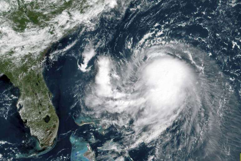
With a top wind speed of 75 mph (120 kph) Saturday morning, Henri sped up slightly to move north-northeast at 14 mph (23 kph). It’s still about 465 miles (750 kilometers) south of Montauk on New York’s Long Island.
Regardless of its exact landfall, broad impacts were expected across a large swath of the Northeast, extending inland to Hartford, Connecticut, and Albany, New York, and eastward to Cape Cod, which is teeming with tens of thousands of summer tourists. Reflecting Henri’s changing track, a hurricane watch was lifted for the Cape on Saturday, though it remained under tropical storm and storm surge warnings.
The National Hurricane Center said late Saturday morning that a hurricane warning for the southern coast of New England, including Rhode Island, was being extended eastward, encompassing Block Island. It said a tropical storm warning for the coast of Massachusetts had been extended eastward, including Nantucket.
Massachusetts Gov. Charlie Baker urged people vacationing on the Cape to leave. One state down, Gov. Ned Lamont warned Connecticut residents they should prepare to “shelter in place” from Sunday afternoon through at least Monday morning as the state braces for the first possible direct hit from a hurricane in decades.
“We haven’t been down this road in quite a while and there’s no doubt that we and the rest of New England would have some real difficulties with a direct hit from a hurricane,” said Michael Finkelstein, police chief and emergency management director in East Lyme, Connecticut.
Storm surge between 3 and 5 feet (1 to 1.5 meters) is possible from Flushing, New York, to Chatham, Massachusetts, and for parts of the North Shore and South Shore of Long Island, the hurricane center said.
Rainfall between 3 to 6 inches (7.5 to 15 centimeters) is expected Sunday through Monday.
The weather service warned of the potential for damaging winds and widespread coastal flooding, and officials in Massachusetts, Connecticut and New York cautioned that people could lose power for a week or even longer. Authorities advised people to secure their boats, fuel up their vehicles and stock up on canned goods.
New York state park officials were building a wall of sand along the boardwalk at Jones Beach to protect it against surging tides, said George Gorman, the regional director for state parks on Long Island. The wall was being built with equipment procured in the wake of Sandy, he said.
Campgrounds were expected to be closed and remain off limits until Tuesday.
At Safe Harbor Marina in coastal Plymouth, Massachusetts, Steve Berlo was among the many boaters having their vessels pulled out of the water ahead of the storm.
“It’s rare, but when it happens, you want to be sure you’re ready,” said Berlo, 54. “Got to protect our second home.”
In the Hamptons, the celebrity playground on Long Island’s east end, officials warned of dangerous rip currents and flooding that’s likely to turn streets like the mansion-lined Dune Road into lagoons.
Ryan Murphy, the emergency management administrator for the Town of Southampton, said that while the storm’s track continues to evolve, “we have to plan as if it’s going to be like a Category 1 hurricane that would be hitting us.”